


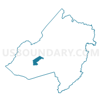
Chester township voting district 1, Morris County, New Jersey
About
Outline

Summary
| Unique Area Identifier | 621059 |
| Name | Chester township voting district 1 |
| County | Morris County |
| State | New Jersey |
| Area (square miles) | 5.09 |
| Land Area (square miles) | 5.07 |
| Water Area (square miles) | 0.02 |
| % of Land Area | 99.62 |
| % of Water Area | 0.38 |
| Latitude of the Internal Point | 40.82082510 |
| Longtitude of the Internal Point | -74.66779230 |
Maps

Graphs
Select a template below for downloading or customizing gragh for Chester township voting district 1, Morris County, New Jersey


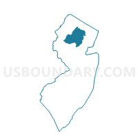
Neighbors
Neighoring Voting District (by Name) Neighboring Voting District on the Map
- Chester borough voting district 1, Morris County, NJ
- Chester township voting district 2, Morris County, NJ
- Chester township voting district 4, Morris County, NJ
- Chester township voting district 5, Morris County, NJ
- Mount Olive township voting district 1, Morris County, NJ
- Mount Olive township voting district 2, Morris County, NJ
- Mount Olive township voting district 3, Morris County, NJ
- Mount Olive township voting district 4, Morris County, NJ
- Randolph township voting district 12, Morris County, NJ
- Randolph township voting district 13, Morris County, NJ
- Roxbury township ward 4 voting district 2, Morris County, NJ
- Roxbury township ward 4 voting district 3, Morris County, NJ
- Roxbury township ward 4 voting district 5, Morris County, NJ
Top 10 Neighboring County Subdivision (by Population) Neighboring County Subdivision on the Map
- Mount Olive township, Morris County, NJ (28,117)
- Randolph township, Morris County, NJ (25,734)
- Roxbury township, Morris County, NJ (23,324)
- Chester township, Morris County, NJ (7,838)
- Chester borough, Morris County, NJ (1,649)
Top 10 Neighboring Place (by Population) Neighboring Place on the Map
Top 10 Neighboring Elementary School District (by Population) Neighboring Elementary School District on the Map
Top 10 Neighboring Secondary School District (by Population) Neighboring Secondary School District on the Map
Top 10 Neighboring Unified School District (by Population) Neighboring Unified School District on the Map
- Mount Olive Township School District, NJ (28,117)
- Randolph Township School District, NJ (25,734)
- Roxbury Township School District, NJ (23,324)
Top 10 Neighboring State Legislative District Lower Chamber (by Population) Neighboring State Legislative District Lower Chamber on the Map
Top 10 Neighboring State Legislative District Upper Chamber (by Population) Neighboring State Legislative District Upper Chamber on the Map
Top 10 Neighboring 111th Congressional District (by Population) Neighboring 111th Congressional District on the Map
Top 10 Neighboring Census Tract (by Population) Neighboring Census Tract on the Map
- Census Tract 459.02, Morris County, NJ (7,838)
- Census Tract 461.03, Morris County, NJ (6,251)
- Census Tract 457.01, Morris County, NJ (6,003)
- Census Tract 455.01, Morris County, NJ (5,227)
- Census Tract 459.01, Morris County, NJ (1,649)